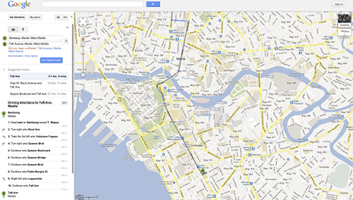
Directions by Metro Manila trains now in Google Maps
Residents of Metro Manila can now plan trips around the city in Google Maps using the metro’s four train lines — the LRT1, LRT2, MRT3, and the PNR Commuter Train.
To use this new feature, click on the “Get Directions” button, type the origin and destination points in the maps search bar, select the train icon, and press “Get Directions” again.
Google Maps will then provide multiple options for routes, the nearest train station, where to transfer trains, how long the journey will take, and how much it will cost.
Commuters can also choose when you want to leave or for Google to optimize the route based on “less walking” or “fewer train transfers.”
This public transit feature will make it easier for more Filipinos to plan their routes while take public transport. Large metropolitan areas like Manila rely on public transport to efficiently move people around, and Google Maps is primed to foster greater usage of this transport infrastructure.
After joining Google Maps, the Burbank transit agency in Los Angeles saw a 25-percent increase in patronage.
To get the transit information on the map, Google worked with Eacomm Corporation, a Web and software development company based in Quezon City.
Now with the four main metro train lines launched, Google said its moving forward with Eacomm on expanding public transport options on the map for more locations and transit types in the Philippines.
How to use public transport directions on Google Maps
1. Go to Google Maps.
2. Click on “Get Directions” in the upper left.
3. Click on the public transport icon (looks like a train, next to the car).
4. Enter your starting point in Box A and your destination in Box B. Choose “Leave now” or set your own departure time.
5. Click on “Get Directions” to see three suggested routes and the estimated travel time.
6. Mouse over each route to see each one on the map; scroll down to see step by step instructions, including info like bus numbers and how to walk to the nearest bus, train, or ferry stop.
7. To customize your trip, click “Show options.” Then choose your preferred transit mode (e.g. bus or train) or options like “fewer transfers” or “less walking”.
How to use google maps to find things to do… not just how to get there
You can use Google Maps to search for much more than just directions. The search box within Google Maps will help you find restaurants, shops, and other places of interest, along with reviews and photos. And directions to that hot new spot are just a click away.
1. Let’s say you’ve heard there are great restaurants in Makati. Type “Makati restaurants” in the search box at the top of the page of Google Maps.
2. You’ll see a bunch of pins on the map, and a list of restaurants in the left-side panel.
3. Scroll around, click on some reviews, and choose a restaurant.
4. Click on the restaurant’s pin icon on the map, and click on “Directions” in the pop-up box.
5. Fill in box A with your location (it may be automatically detected if you’re on your phone). The restaurant’s address will appear in box B. Click on the public transport icon and then “Get Directions.”
Please read the original article here.


